|
|
|
Geodetic Strain used to improve earthquake forecasts in the
San Francisco Bay Region
Since H.F. Reid’s classic study of the 1906 San Francisco earthquake,
we have known that elastic strain accumulates slowly over centuries but
is released suddenly in great earthquakes. In Reid’s day crustal
strain was measured by repeated triangulation surveys, starting in the
1960’s with laser distance measuring devices, and in the last few
decades with continuous GPS networks. Geodetic strain plays a
central role in forecasting future seismic hazards: the higher
the rate of strain accumulation, either the more frequent or the larger
the earthquakes must ultimately be to relieve that strain. One of
our most important goals is to quantify these relations.
To accomplish this we require the most accurate measurements possible,
mechanically consistent physical models of the strain accumulation
process, and inversion methodologies to relate the data to the unknown
model parameters. With former student Kaj Johnson (Univ. Indiana)
we are applying these ideas to the San Francisco Bay area where several
major faults present significant hazards. Our goals are to
better constrain estimates of the long-term slip rates on these faults
and the average recurrence times of damaging earthquakes. We are
investigating how geodetic strain measurements can reduce uncertainties
in fault slip-rates and recurrence times inferred from paleoseismic
investigations.
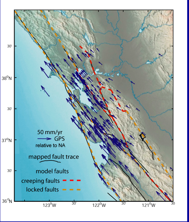
Figure 1: Average GPS velocities in the San
Francisco Bay region shown relative to stable North America. Also
shown are major creeping and locked faults.
Kaj has extended earlier two-dimensional models of faults in an elastic
layer overlying a viscoelastic lower crust and upper mantle to three
dimensions. This approach accounts for the long-term motion of
crustal blocks, but better accounts for geometric complexities where,
for example, thrust faults must accommodate motion oblique to the major
strike-slip faults. The deformation is rigorously coupled to the
visco-elastic substrate and we account analytically for an infinite
sequence of past repeating earthquakes.
The estimation strategy is based on a Bayesian analysis, where we take
the paleoseismic estimates of fault slip-rate and recurrence time as a
priori estimates (assumed to have uniform distribution between broad
lower and upper bounds). We then analyze the geodetic data and
compute posterior probability distributions on parameters of interest,
such as slip-rate and recurrence time.
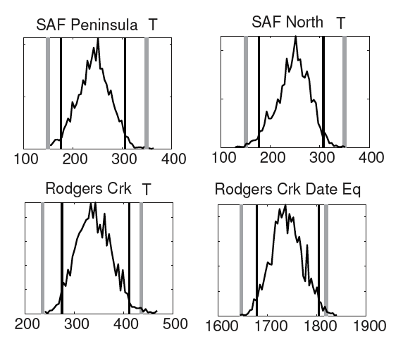
Preliminary results demonstrate that the geodetic data provide strong
constraints on slip-rate as expected. For example the San Andreas
slips at rates near 33 mm/yr south of the Bay Area, but drops to below
15 mm/yr on the San Francisco Peninsula as slip is transferred to the
Hayward and Calaveras faults. The uncertainty in the recurrence
times of large earthquakes is only slightly reduced by adding the
geodetic observations: to 180-300 years on the San Andreas, vs 270-400
years on the Rogers Creek Fault. Further work will be required to
improve the mechanical forward models and to understand whether the
bounds on the recurrence times can be narrowed further.
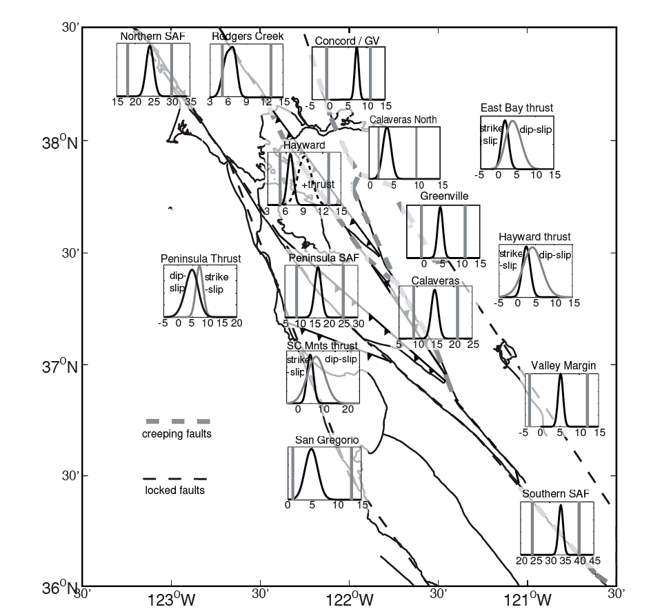
Figure 2. Posterior probability density functions
for slip-rates on major fault segments. Prior bounds are shown by
gray bars.
Figure 3. Recurrence times for large earthquakes on
the San Andreas Fault Peninsula (upper left), north of the Bay (upper
right), and Rogers Creek fault (lower left). The most recent
earthquake on the San Andreas is 1906. Estimates of the most
recent large quake on the Rogers Creek Fault are shown in the lower
right. Grey bars represent prior bounds. Dark bars represent 95%
confidence intervals on the posterior distribution.
|